Friday, May 03, 2024
34.0°F

Preview of summer is over

by CHERYL SCHWEIZERStaff Writer
Staff Writer | April 12, 2016 6:00 AM

photo

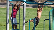
Karlito Oliveras (right) and his sister Aaliyah take to the bars at Montlake Park Friday evening. The weather provided a preview of summer over the weekend, but clouds and rain are forecast to return this week.

MOSES LAKE — The weather gods gave the Columbia Basin a warm sunny weekend, a real preview of summer, and this week will snatch it all away.

Temperatures topped out in the high 70s and low 80s over the weekend, about 15 degrees over the normal temperature for Moses Lake in early April, said Jeff Kote, meteorologist with the National Weather Service office in Spokane. The normal daytime high is about 63 degrees.

But all that changes this week with the arrival of a chance of rain Tuesday night. Temperatures drop back to the upper 60s, more normal for mid-April. Wednesday’s high is forecast to be 64 degrees, with mostly cloudy skies and a 20 to 30 percent chance of rain. Thursday there’s a 40 percent chance of rain, with a high around 57 degrees. It’s a straight run of mostly cloudy skies for the week.

But even temperatures that drop by 15 degrees are still a little bit warmer than normal for early April, Kote said. The normal average high temperature for April is about 63 degrees, and the normal average low in April is about 36 degrees.

March was both wetter and warmer than normal, Kote said. In fact precipitation was about double what Moses Lake usually gets in March. The city got 1.52 inches of precipitation in March; normal average precipitation for the month is about .78 inches.

Average temperature in March was about 2 degrees higher than normal, he said. The average temperature for March 2016 was 57.5 degrees, compared with a historic normal of 55.1 degrees. The average normal low in March was 34.1 degrees, compared with the historic normal low of 31.9 degrees.

The National Weather Service did forecast warmer temperatures for March, April and May, but below-normal precipitation. The region is (or was) under the influence of an El Niño, ocean conditions that traditionally bring warmer and drier weather to Pacific Northwest.

But El Niño 2015-16 flouted tradition – it did mean warmer weather in some places, but it also brought way more precipitation than forecast. Kote said the El Niño phenomenon has its highest correlation in winter. “We’re kind of beyond (its influence) right now.”

Kote said the weather service forecasters are saying there’s an above-average chance of less precipitation and warmer temperatures than normal in April and May.

Cheryl Schweizer can be reached via email at education@columbiabasinherald.com.