Sunday, May 05, 2024
57.0°F

Surveying job is "anything but boring" -Jeff Curtis

by Royal Register EditorTed Escobar
| January 20, 2013 5:05 AM

photo

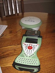
The top piece in this trio of GPS equipment finds and locks onto the satellites (9 or 10). The black piece tranfers the information from the satellites to the third piece, and it translates everything to understandable language for Curtis. With this technology he can pinpoint his location to within one-fourth of an inch of perfect.

DESERT AIRE - You might wonder why anyone would want to stand out in the open and measure and chart land masses.

"It's anything but boring," says Desert Aire surveyor Jeff Curtis.

The first thing Curtis likes about surveying is the very act of working outdoors. He likes the history he uncovers and the changing technology with which he works.

"Every job is different. You never deal with the same situation twice," he said.

Curtis started his surveying career 35 years ago, right out of high school in Wenatchee. He landed a summer job with the Department of Transportation.

"Basically, I followed the surveyors around," he said. "I ended up liking it."

Curtis eventually took the two-day, 16-hour licensing exam that included algebra, geometry and trigonometry. He passed, but "that was the hard way," and Curtis recommends that aspiring surveyors go to college.

"There were years I took it that nobody passed," he said.

Curtis is as much a student of surveying as a practitioner. He's like a walking encyclopedia.

According to Curtis, an act of Congress in 1785 ordered the surveying of the entire U.S. as it was then and would be into the future. Hundreds, perhaps thousands of people were involved. They went out as large crews, which included cooks and chuck wagons, and lived in tents.

These crews were charged with mapping the country into townships. These are land masses six miles square, or 36 square miles. They are bordered by north-south township lines and east-west range lines.

Although people are allowed to buy land in all shapes and sizes, townships were ordered to be exact. A further sub-division, the section (640 acres) was ordered to be exactly one mile square.

One of the later states to be surveyed was Washington. The survey was started in the early 1880s, when it was still a territory, and completed in 1889, in time for statehood.

The work of the early surveyors was not easy. They used 66-foot long steel chains, laid out 80 times, to measure a mile. And they had to do it in a straight line. The used the sun and the stars to figure out where they were.

Those surveyors came close in nearly every case, but they were not perfect. Today, when neighboring property owners in a dispute find that the original survey was off, they must accept the original survey as law, Curtis said. One comes up short.

When Curtis started his career, the standard equipment was transits and steel tape measures. Electronic measuring devices were introduced in the 1980s. The 1990s brought the first GPS.

But early GPS was not easy. There were few satellites, and you could work only when they were overhead.

"I had to do the Boeing plant in Everett between midnight and 5 a.m.," Curtis said.

Now there are satellites overhead at all times, lots of them. Curtis usually locks onto nine or 10 when he works.

"The more satellites, the more accurate," he said.

With GPS, Curtis works alone. He can survey a mile in seconds. And he doesn't have to travel a straight line to the distant point he seeks. GPS finds it. He can travel miles around and still end up at the right place.

There are three units that work together in the GPS system. One finds and locks onto the satellites. The second relays information (100 signals per second from each satellite) from the first to a translating device which tells Curtis exactly where he is.

"It talks to you. It's amazing stuff," he said.

Curtis ended up in Desert Aire because of the economy. He was living and working in western Washington when the housing development industry on which he depended faltered.

Curtis and his wife Robin had built a retirement home in Desert Aire in 2006. Since they couldn't support two homes, they sold out in western Washington in 2008 and relocated the business.

"We moved here because of the quality of life," Curtis said.

There was a slow re-start to the business, Curtis said, but it has picked up and is growing.

Most jobs are fairly uneventful, but occasionally there is one for the memory bank. Curtis once surveyed a gold mine to assure the owner the tunnel was on his property.

Another rare assignment was the mapping of the bottom of the Chelan River at Chelan Falls. A high water event had washed a piece of it out. The goal was to put the washed out materials exactly where it belonged.