Saturday, May 04, 2024
57.0°F

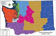
Redistricting map shuffles districts in Columbia Basin

by Herald Staff WriterRyan Lancaster
| January 4, 2012 5:00 AM

photo

The Washignton State Redistricting Commission released a final plan for new congressional districts Sunday.

MOSES LAKE - The Washington State Redistricting Commissioners reached an eleventh hour agreement on new congressional and legislative boundaries.

The commission, made up of two Republicans and two Democrats, is tasked every decade with redrawing the boundaries to redistribute shifting populations evenly into each district.

Republican Commissioner Tom Huff negotiated Eastern Washington's legislative district lines with Democrat Dean Foster.

Their final plan stretches the 13th District into a broad belt across Washington's middle with the transfer of Lincoln County from the 7th District.

A larger portion of Okanogan County and the northwest corner of Grant County are drawn into the 12th District along with the whole of Soap Lake, although the cities of Quincy and Ephrata are kept intact within the 13th District.

The northern portion of Grant County remains in the 12th District, including the Grand Coulee Dam region.

The 13th District drops the top half of Yakima County, which is drawn into a re-crafted 15th District including much of the Yakima Valley.

With a more than 54 percent Latino population, the 15th would be Washington's first majority Latino district, bringing the total number of minority-majority legislative districts to four.

Thirteenth District Rep. Judy Warnick, R-Moses Lake, said she was surprised to see the whole of Lincoln County brought under her representation.

"I don't know if the geographical district is the largest now but it's got to be close because we go from King (County) to Spokane (County) - all the way across the state in a long, thin district," she said; adding she looks forward to meeting new constituents. "It won't be that different to represent Lincoln County because I have connections there but we're going to be putting a lot of miles on our cars."

She noted the number of common interests between the counties contained within the new 13th District, including issues concerning transportation, agriculture and water.

"The small towns we represent in Grant and Kittitas counties are no different than the small towns in Lincoln County," she said.

On the congressional side, a plan drawn up by Republican Commissioner Slade Gorton and Democrat Tim Ceis transfers Okanogan County and parts of Adams and Walla Walla counties into the 4th District from the 5th District.

Chelan and Kittitas counties, including Wenatchee, Ellensburg and the Columbia River Gorge, would meanwhile be shifted from the 4th District into the 8th District.

Ceis and Foster issued a joint statement Monday noting that for all its challenges, the redistricting process proved itself for the third time since it was adopted by the state in 1983.

"This is a bipartisan process and it is always a challenge dealing with competing objectives," they stated. "But we have reached a fair and equitable resolution that will serve the citizens of Washington well."

Among what they billed as several "historic" changes in the adopted plan were the addition of a 10th Congressional district, the majority-minority 15th legislative district and a majority-minority 9th congressional district.

"The adopted legislative and congressional plans strive to equalize population, minimize unnecessary city and county splits and keep communities of interest intact," they stated. "The amount of public comment we heard throughout the process was instrumental in helping us make this determination and we thank the public for their participation."

The commission gathered input on the process by soliciting online comments, speaking with county auditors and holding 18 public hearings across the state, including a forum at Big Bend Community College in July.

The goal was to redraw boundaries to encompass 672,454 in each congressional district and 137,235 people in each legislative district.

In Grant County, District 4 needed to shed nearly 102,000 people while District 14 had to lose 6,514 people.

A final report to the state Legislature will be published Jan. 9 and will include more detailed district maps, according to Genevieve O'Sullivan, the commission's communications director.

The Legislature has 30 days beginning the first day of the 2012 regular session to review and make any changes to the final plan. Only 2 percent population changes per district are allowed, and those changes require a two-thirds vote of both houses to pass.

After the 30 day review period has passed, with or without legislative action, the final plan becomes law, O'Sullivan said.

More details of the commission's plan can be found at www.redistricting.wa.gov.